Dataset Summary
The data collection occurred from September 2023 to February 2024, encompassing diverse settings such as roads in a vegetated campus and tunnels on highways. Each route was traversed multiple times to facilitate place recognition evaluations. The sensor suite included a 3D lidar, 4D radars, stereo cameras, consumer-grade IMUs, and a GNSS/INS system. Sensor data packets were synchronized to GNSS time using a two-step process: a convex hull algorithm was applied to smooth host time jitter, and then odometry and correlation algorithms were used to correct constant time offsets. Extrinsic calibration between sensors was achieved through manual measurements and subsequent nonlinear optimization. The reference motion for the platforms was generated by registering lidar scans to a terrestrial laser scanner (TLS) point cloud map using a lidar inertial odometry (LIO) method in localization mode. Additionally, a data reversion technique was introduced to enable backward LIO processing. We believe this dataset will boost research in radar-based point cloud registration, odometry, mapping, and place recognition.
Sequences
The three platforms share almost the same sensor rig as the data collection was carried out sequentially across these platforms. The published dataset includes 44 sequences: 6 handheld sequences, 14 e-bike sequences, and 24 SUV sequences. More than half of these sequences were captured under special conditions such as rain, dusk, and night. The dataset encompasses various scenes including campus environments, highways, and tunnels. For place recognition purposes, data for each route were captured at least three different times. Additionally, each sequence was recorded with roughly the same start and end poses.
There are a total of eight routes: the basketball court, the starlake, the software school, the starlake tower, the info faculty, the info and arts faculty, the info arts and engineering faculty, and the August 1 road. Since the Wuhan University main campus consists of three segments, the info faculty, the arts and sciences faculty, and the engineering faculty, we collected data on three incremental routes spanning these segments, featuring urban roads in the campus.
-
The basketball court is a small flat area surrounded by some buildings.
-
The starlake route traverses the campus, featuring dense vegetation.
-
The software school route passes through urban canyons formed by tall buildings.
-
The starlake tower route encircles the high-rise starlake tower.
-
The August 1 road route is a highway including a long tunnel.
Trajectories
There are a total of eight routes, as follows: the basketball court, the starlake, the software school, the starlake tower, the info faculty, the info and arts faculty, the info arts and engineering faculty, and the August 1 road. The basketball court is a small flat area surrounded by some buildings. The starlake route traverses the campus, featuring dense vegetation. The software school route passes through urban canyons formed by tall buildings. the starlake tower route encircles the high-rise starlake tower. Since the Wuhan University main campus consists of three segments, the info faculty, the arts and sciences faculty, and the engineering faculty, we collected data on three incremental routes spanning these segments, featuring urban roads in the campus. The August 1 road route is a highway including a long tunnel.
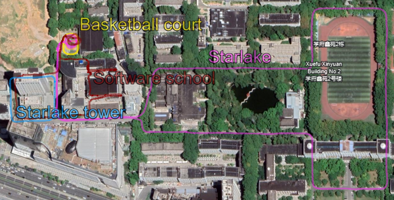
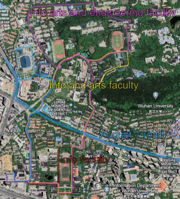
The routes used for data collection in our dataset. The top plot shows four routes: the basketball court (yellow), the starlake (pink), the software school (brown), and the starlake tower (blue). The bottom plot shows the other four routes: the info arts and engineering faculty (pink), the info and arts faculty (yellow), the August 1 road (blue), and the info faculty (brown).